Investigation of land subsidence in the Fenhe River Basin, northern China, using Sentinel-1 InSAR time series analysis, to support hazard mitigation and groundwater management
Published in August 21, 2025
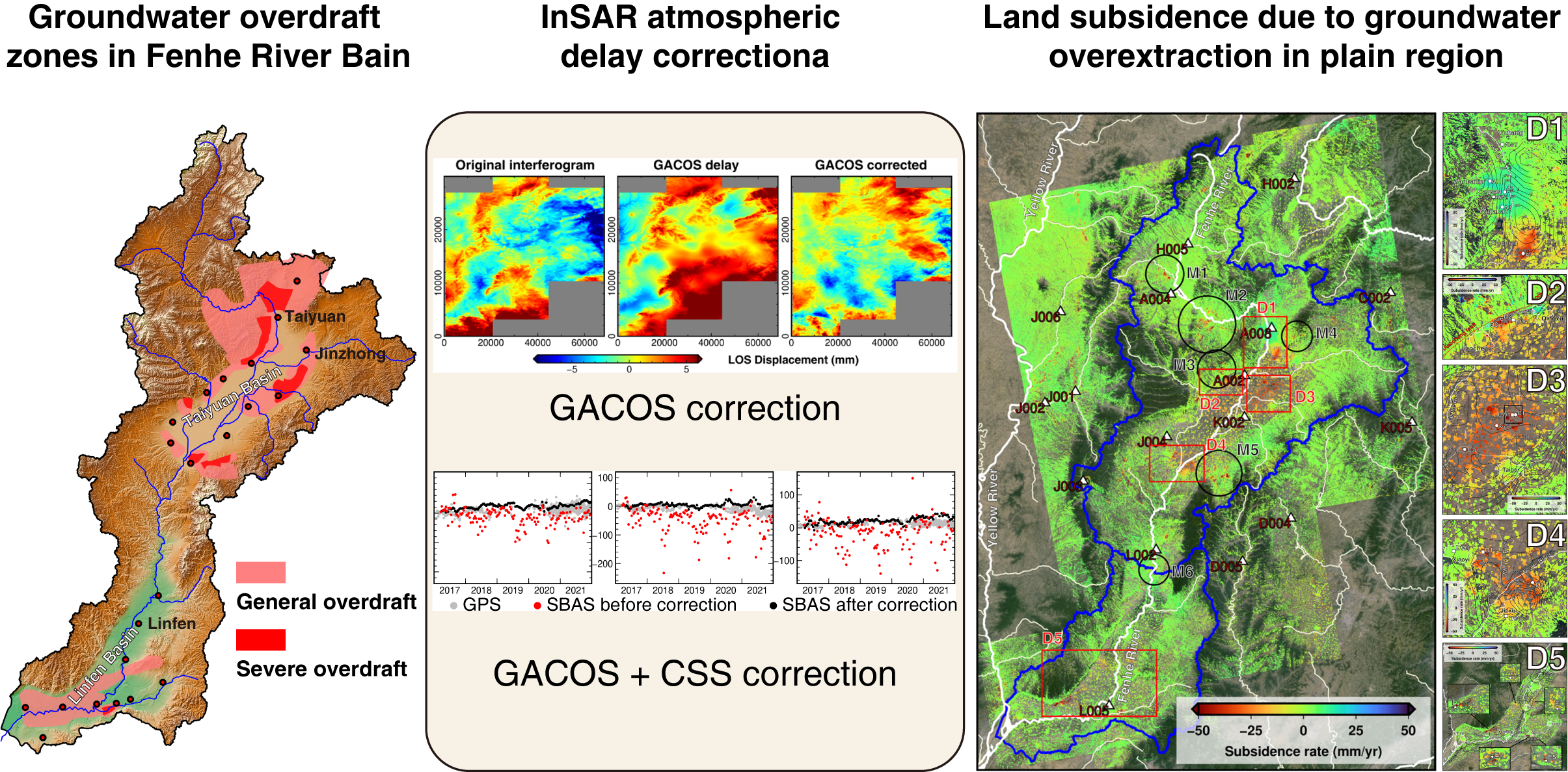
The Fenhe River Basin, a semiarid region in northern China, faces severe land subsidence driven by groundwater overexploitation and underground coal mining, threatening regional sustainability. This study employs multi-temporal Sentinel-1 SAR data (2017–2021) processed through advanced InSAR techniques, integrated with GACOS (Generic Atmospheric Correction Online Service) and CSS (Common Scene Stacking) atmospheric corrections, to generate the first basin-wide deformation map through seamless merging of adjacent satellite tracks. Our analysis reveals three principal deformation regimes: (1) Aquifer-system compaction - widespread subsidence (≤ 81 mm/yr) in agricultural plains, driven by irrigation pumping with seasonal deformation cycles (annual periodicity with 40 mm peak-to-peak amplitude) synchronous with groundwater level fluctuations; (2) Urban aquifer recovery – land uplift signals (≤ 20 mm/yr) in urban areas of Taiyuan and Qingxu, reflecting aquifer recovery from reduced extraction; (3) Mining-induced subsidence - accelerated deformation (≤ 87 mm/yr) in coal-rich mountainous areas, exhibiting abrupt displacement signatures during active extraction phases. The technical innovation of combining model-based (GACOS) and data-driven (CSS) atmospheric corrections proves particularly effective for large-scale InSAR implementation in topographically complex basins. The combined use of GACOS and CSS primarily offers a twofold advantage: (1) enhanced accuracy in atmospheric correction, and (2) mitigation of systematic offsets in deformation measurements within overlapping areas between adjacent satellite tracks. Results validate the success of groundwater management policies in stabilizing aquifer systems while highlighting persistent challenges in agricultural water use depending on groundwater irrigation. This work establishes a replicable monitoring framework for sustainable water resource management in groundwater-dependent basins globally, emphasizing the necessity of integrating satellite geodesy with adaptive water governance strategies.
汾河流域位于中国北方的半干旱地区,因地下水过度开采和地下煤矿开采导致严重的土地沉降,威胁到区域的可持续性。本研究利用多时相的Sentinel-1 SAR数据(2017–2021),通过先进的InSAR技术处理,并结合GACOS(通用大气校正在线服务)和CSS(常见场景堆叠)大气校正,生成了首个全流域变形图,通过无缝合并相邻卫星轨道数据。我们的分析揭示了三种主要的变形机制:(1)含水层系统压实——在农业平原上普遍发生的沉降(≤ 81 mm/yr),由灌溉抽水驱动,具有季节性变形周期(年周期,峰值到峰值振幅为40毫米),与地下水位波动同步;(2)城市含水层恢复——太原和清徐的城市地区出现地面抬升信号(≤ 20 mm/yr),反映了由于减少抽水而导致的含水层恢复;(3)采矿引发的沉降——煤矿丰富的山区发生加速变形(≤ 87 mm/yr),在活跃开采阶段表现出突发的位移特征。结合基于模型的GACOS和基于数据的CSS大气校正的技术创新,尤其在地形复杂的流域中进行大规模InSAR应用时,证明了其有效性。GACOS和CSS的结合主要提供了双重优势:(1)增强了大气校正的准确性;(2)减轻了相邻卫星轨道重叠区域变形测量中的系统性偏差。研究结果验证了地下水管理政策在稳定含水层系统方面的成功,同时突显了依赖地下水灌溉的农业用水面临的持续挑战。该研究为全球地下水依赖流域的可持续水资源管理建立了可复制的监测框架,强调了将卫星大地测量与适应性水治理策略相结合的必要性。
Graphical Abstract