Characterizing aquifer properties in the Taiyuan Basin, Northern China, using ground deformation from Sentinel-1 InSAR time series analysis
Published in March 13, 2025
- Study region
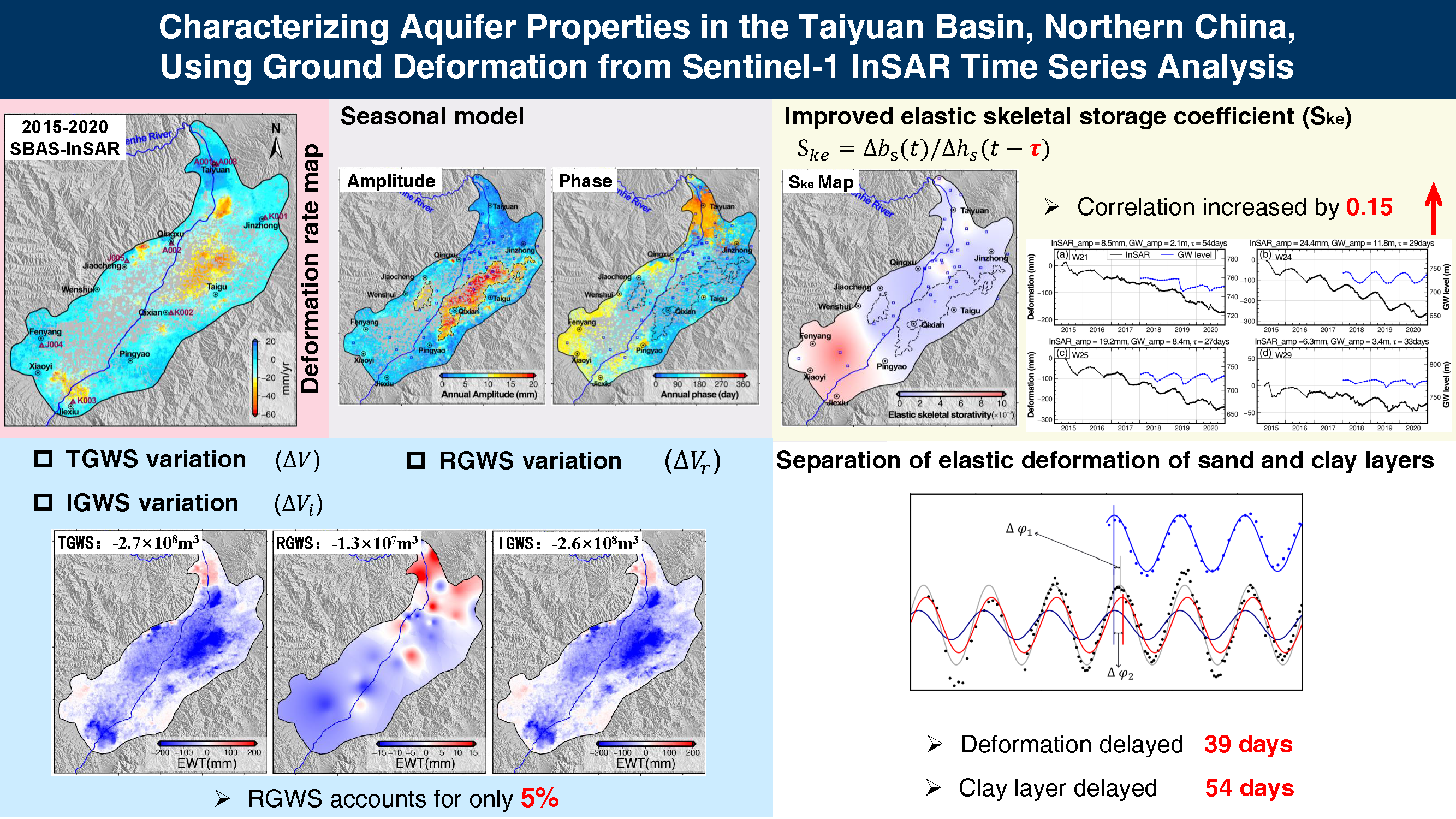
The Taiyuan Basin in northern China, a semi-arid region where prolonged groundwater overexploitation has resulted in severe land subsidence and irreversible aquifer storage loss.
- Study focus
By integrating Sentinel-1 InSAR time series analysis (2015–2020) and groundwater level measurements, we developed a geophysical model to quantify seasonal deformation signals and the time-lagged relationships between land subsidence and groundwater level changes. Through incorporating time-lag corrections, we refined estimations of the elastic skeletal storage coefficient and groundwater storage variations. A novel method was proposed to separate elastic deformations in sand and clay layers based on their distinct hydraulic response characteristics.
- New hydrological insights for the region
Land subsidence lags groundwater level changes by an average of 39 days, revealing delayed compaction dominated by low-permeability clay layers. Recoverable groundwater storage accounts for merely 5 % of total losses, indicating that most of subsidence results from inelastic clay compression, which underscores a critical risk of permanent aquifer storage capacity depletion. The observed 54-day delayed response in clay layers correlates with their thickness and multi-layered structure, offering critical parameters for predicting the structure of multi-layered aquifer systems. This study systematically elucidates the groundwater-subsidence coupling mechanisms, providing new insights for characterizing over-exploited aquifers and advancing sustainable groundwater resource management worldwide.
- 研究区域
太原盆地位于中国北方,是一个半干旱地区,长期的地下水过度开采导致了严重的土地沉降和不可逆的含水层储量损失。
- 研究重点
通过结合Sentinel-1 InSAR时间序列分析(2015–2020)和地下水位测量数据,我们开发了一个地球物理模型,用于量化季节性变形信号及土地沉降与地下水位变化之间的时间滞后关系。通过引入时间滞后修正,我们精细化了弹性骨架储存系数和地下水储量变化的估算。我们提出了一种新方法,根据砂层和粘土层的不同水力响应特征,将弹性变形分离开来。
- 该区域的新水文见解
土地沉降相较于地下水位变化滞后平均39天,揭示了由低渗透性粘土层主导的滞后压实现象。可恢复的地下水储量仅占总损失的5%,表明大部分沉降是由非弹性粘土压缩引起的,这凸显了含水层储量永久性枯竭的关键风险。粘土层观察到的54天滞后响应与其厚度和多层结构相关,为预测多层含水层系统的结构提供了关键参数。本研究系统地阐明了地下水与沉降之间的耦合机制,为表征过度开采的含水层并推进全球可持续地下水资源管理提供了新的见解。
Graphical Abstract